Summary of Smoke Related Joint Fire Science Program Grants Relevant to the Southeastern U.S.
1Tall Timbers Research Station, Tallahassee, Florida
Publication ID: Fact Sheet 2018-3 Published: 2018 Revised: 2026
(View PDF)
Introduction
This fact sheet summarizes smoke research relevant to the southeastern U.S. funded by the Joint Fire Science Program (JFSP) as presented in the publication, “A compendium of brief summaries of smoke science research in support of the Joint Fire Science Program Smoke Science Plan” (April 21, 2017). These studies fall under four general themes: emissions inventory, model validation, populations and smoke, and potential future fire and air quality. Final reports for all these projects are available on the JFSP website at https://www.firescience.gov/JFSP_research.cfm.
Emission Inventory
Ozone and Particulate Matter
To better evaluate adherence to current national ambient air quality standards (NAAQS), air quality managers require increasingly detailed information on the spatial pattern and frequency of smoke and its contribution to ozone and fine particulate matter (PM2.5). The DEASCO3 and PMDETAIL projects have improved emission inventories for wildfire, prescribed fire, and agricultural fire and include a web map toolset that allows managers to examine the various databases, ozone monitoring data, fire emissions data, and modeling results from across the U.S. (PI Tom Moore). In peat fires, remote sensing measurements of water table depth and soil moisture showed that deeper, denser peat had higher emissions of PM2.5 per biomass consumed (PI Brian Benscoter).
Secondary Organic Aerosols (SOA)
Secondary organic aerosols form from volatile organic compounds (VOCs, emitted from fire and other combustion sources) through their exposure to sunlight. VOCs are diverse, which makes the spectrum of SOAs produced complex and difficult to characterize. Current studies are working to better catalog SOA precursors, especially non-methane organic compounds (NMOCs), and model their formation using past research and new data (PI Kelley Barsanti). Distinguishing between emissions from fires and emissions from other sources (e.g., fossil fuel combustion) is also difficult but important for determining potential effects of fire on air quality standards and public health. To track smoke emissions, chemical markers indicating biomass combustion are used. Levoglucosan has often been used as a marker, but it decays during plume aging which can result in models underestimating the contribution of wildland fire smoke to ambient fine particulate matter. To create more accurate monitoring at longer times since emission, nitrocatechols have been proposed as a new marker for SOAs (PI Jeff Collett).
Emission and Inventory Assessments
Burned area estimates in rangelands based solely on MODIS satellite active fire detections were frequently under estimated, while burned area using the MCD64 burned area product (derived from MODIS active fire detections and surface reflectance imagery) tended to detect more burned regions than Landsat based MTBS (Monitoring Trends in Burn Severity). The greatest source of uncertainty in emission inventories is fuel load consumed and this is especially true for forests (PI Wei Min Hao).
Mapping and Information Systems
Accurate assessments of fuel types and fuel loading are critical for modelling smoke emissions transport and air quality. To aid in accurate assessments, new fuel loading data and population data were added into the Fuel Characteristic Classification System (FCCS) database. It combined many of the largest datasets which will help in further discussion on how best to categorize fuels and produce accurate model results (PI Nancy French).
Fire and Smoke Validation
Air Quality Models
CMAQ, CALPUFF, DAYSMOKE, BlueSky
Models predicting smoke transport, and its concentration in total or by constituent, are important to fire managers and air quality regulators but require validation by field tests. A common model for estimating air quality from wildland fires is the Community Multi-scale Air Quality model (CMAQ; URL: https://www.epa.gov/cmaq/wildland-fires-cmaq). This model is reasonably accurate when modelling a single fire but decreases performance over a regional scale or with multiple fires (PI Talat Odman). Results obtained using multiple updraft core data processed through DAYSMOKE can be used to improve the accuracy of CMAQ (PI Yong Liu). CMAQ is also improved with use of an adaptive grid (AG-CMAQ) where grid resolution changes continuously to improve the ability of the model to capture detailed dynamics or follow chemical evolution of plumes (Garcia-Menendez et al., 2010). PM2.5 estimates using CMAQ were very sensitive to wind direction and speed and this sensitivity increased as the grid resolution was increased in regional-scale models. This suggests the need for more accurate meteorological inputs and smaller scales to reduce the error in the model output (PI Talat Odman).
Modeling pathways for low intensity burns were validated using the BlueSky framework (URL: https://www.airfire.org/; PI Tara Strand), which variously employs FEPS, CONSUME, CALPUFF and other models. CALPUFF (URL: http://www.src.com/) was found to consistently underestimate ground level air pollution from fires. DAYSMOKE accurately estimated ground level PM2.5 concentrations within a 3-6 mile distance from a single fire or small number of fires (PI Talat Odman).
Plume Height Models
DAYSMOKE, WRAP, FEPS, Briggs
Accurate plume height estimates and their injection into vertical atmospheric layers are important for modeling regional-scale air quality. One project compared field measurements and predictions of plume heights using several models (DAYSMOKE, WRAP, FEPS, Briggs Plume Rise) of 20 prescribed fires in the Piedmont and Coastal Plain regions of the southeastern U.S. Despite fluctuations in the vertical structure of smoke plumes over differing time scales, plume heights were estimated with reasonable accuracy using the inputs fuel temperature, fuel moisture, and wind speed (PI Yong Liu). Of the models tested, DAYSMOKE performed the best while simpler models tended to overestimate smoke plume heights (PI Yong Liu; PI Talat Odman). More evaluation is needed to understand the limitations of WRAP, FEPS, and Briggs plume rise models of burns in the southeastern U.S. (PI Yong Liu).
Modelling Smoke Dispersion Through Tree Canopies
ARPS-CANOPY, FLEXPART, RAFLES, LIDAR
Further progress is being made in our understanding and ability to predict low-intensity surface fire emissions and the effect of forest canopy on smoke dispersion. Tree canopy can greatly influence smoke plume rise and dispersion, making smoke dispersion more horizontal and increasing the potential for impacting smoke sensitive areas. The ARPS-CANOPY model, coupled with the FLEXPART Lagrangian particle dispersion model, has shown promise in improving predictions of sub-canopy smoke behavior. The RAFLES modeling system can be most viable for local small-scale atmospheric responses to surface fires in forested environments (PI Warren Heilman).
Fuel Consumption Models
CONSUME, FOFEM
Accurately predicting fuel consumption is critical for predicting potential emissions as well as other prescribed fire effects. The models Consume (URL: https://www.fs.fed.us/pnw/fera/research/smoke/consume/index.shtml) and FOFEM (First Order Fire Effects Model; URL: https://www.firelab.org/project/fofem) have been shown to predict shrub and herbaceous vegetation consumption accurately for mid-Atlantic and southeastern mixed hardwood, southern pine, and sand pine scrub fuel beds. However, predictions for fine woody fuel, litter, and duff consumption were found to need adjustments, which have been incorporated into the currently available version. A new calibration method for airborne infrared fire temperature sensing has been developed to greatly improve measurements of heat release and rate of fuel consumption over a burn unit (PI Roger Ottmar).
Superfog Models
SAM
Superfog is a dense kind of smoke that has caused major multiple-vehicle accidents in the southeastern U.S. It forms from water vapor condensation on small particles and is very sensitive to small changes in environmental conditions including wind, temperature, fuel moisture content, and humidity. To estimate if superfog formation is favorable or unfavorable, the two-dimensional boundary layer Superfog Assessment Model (SAM) was developed. Its inputs include temperature, relative humidity, atmospheric stability, heat and water vapor produced by a smoldering fuel bed, and fuel bed height. When coupled with other models (e.g. PB-Piedmont), locations can be identified where superfog is most likely to occur. The SAM was validated by laboratory experiments and is capable of predicting historic Superfog events. (PI Marko Princevac).
Empirical Measurements for Model Validation
Airborne and LIDAR experiments on 11 fire incidents have provided a more accurate way of measuring smoke dispersion and plume height by providing empirical data for model validation. The research underscores the importance of combustion efficiency which is strongly related to phase of combustion (flaming, smoldering) in determining fire emissions. Results suggest that LIDAR should be incorporated into future fire-fuel-atmosphere interaction monitoring studies to improve understanding of canopy effects on fires (PI Shawn Urbanski). The Smoke and Emissions Model Intercomparison Project (SEMIP), which has collected a great deal of empirical emissions data to assess model predictions, revealed that diurnal emission profiles (changes over a 24-hour period) have a huge, non-linear effect on the magnitude and location of emissions, although such variations are not well represented in current models (PI Sim Larkin). Fuel consumption databases from around the U.S. have been compiled into one database to assist scientists, modelers, regulators, and managers in validating other fuel consumption models (PI Roger Ottmar).
Populations and Smoke
PM Toxicity and Fuel Type
Wildland fire emissions are known to vary in content, and likely toxicity, with different fuels and burn conditions. One project sought to better understand the toxicity of particulate matter emitted in wildland fire smoke (PI Ian Gilmour). On a toxicity per mass of particulate matter basis, lung toxicity and genetic mutation potencies from wildland fire emissions were shown to be greater in flaming combustion than in smoldering combustion emissions using biomass fuels, including red oak, peat, pine needles, pine, and eucalyptus. However toxicological endpoints resulted in greater responses for smoldering than flaming on an emission factor basis (toxicity per mass of fuel burned). Smoke from pine and eucalyptus had slightly higher toxicological outcomes than the other fuel types (PI Ian Gilmour and Yong Ho Kim).
Public Tolerance of Smoke
Public tolerance of wildland fire smoke has important implications for fire policy and the ability to use prescribed burning as a management tool in the future. In a national study, no statistical differences in the public tolerance of smoke existed between the locations studied (California, Oregon, South Carolina, Montana, Idaho, Texas, and Louisiana; Engebretson et al., 2016). Tolerance of wildland fire smoke varies greatly on an individual basis. Residents who trust fire managers, have a better understanding of the benefits of prescribed fire (PI Troy Hall), or otherwise perceive less risk from smoke emissions tend to be more accepting of wildland fire smoke (PI Eric Toman). Smoke intolerance was mostly driven by health concerns (PI Christine Olsen) or previous adverse health experiences related to wildland fire smoke (PI Troy Hall).
Communication Efforts
Increasing individuals’ awareness of prescribed fire’s benefits and trust in fire managers takes clear and effective communication (PI Troy Hall). Opinions of individuals were influenced the most as a result of increased knowledge of smoke emissions and ability to control their own exposure to smoke. Tolerance can be hindered when individuals are confused by inconsistent messages (PI Eric Toman). For example, residents get confused when the U.S. Forest Service says fire is good for the forest but other public agencies discourage open burning that is actually unrelated to prescribed fire (Olsen et al., 2014). One study also indicated that the public desires advanced warning about potential smoke impacts and issues (PI Troy Hall). Such information was best conveyed through interactive situations (e.g. educational workshops with agency staff) and websites. Television and radio messages were shown to be useful in conveying smoke information while informational brochures and flyers are less useful. Social media also ranked low, which may be a result of most respondents being older aged (PI Christine Olsen). Overall, at the local level, communication efforts tended to be underfunded, understaffed, and conducted by staff with overcrowded schedules who are assigned outreach efforts as an “add-on” responsibility (PI Eric Toman).
Future Fire and Air Quality
Emmisions Impacting Climate Change
Smoke contains several known constituents that contribute to climate change. One such constituent is black carbon, which contributes to warming trends in the Arctic. A project examining black carbon emissions across the U. S. noted that spring burns in the southeastern U.S. contribute relatively little to black carbon transport into the Arctic region despite having the most prescribed fire emissions (PI Sim Larkin). Black carbon estimates were also found to be higher in real time measurements than filter-based measurements of older particulate matter (PI Sonia Kreidenweis). Using spectral reflectance-based remote sensing techniques in northern peatlands, black carbon emissions were found to be fairly constant across all fuel moistures and sources of peat fires (PI Brian Benscoter). Also, organic carbon emission factors (emissions per biomass consumed) were consistently lower in the field compared to laboratory studies. This study also looked at gas-phase emissions that can influence climate change. Using aircraft and ground-based measurements from prescribed burns at Fort Jackson, South Carolina, 97 trace gases were detected, including the first emission factors for a suite of monoterpenes, which are a component of pine litter fuels. Monoterpenes react quickly with ozone to produce secondary organic aerosols contributing to PM2.5 and are important for climate change modelling (PI Sonia Kreidenweis).
Future Fire Intensity and Season
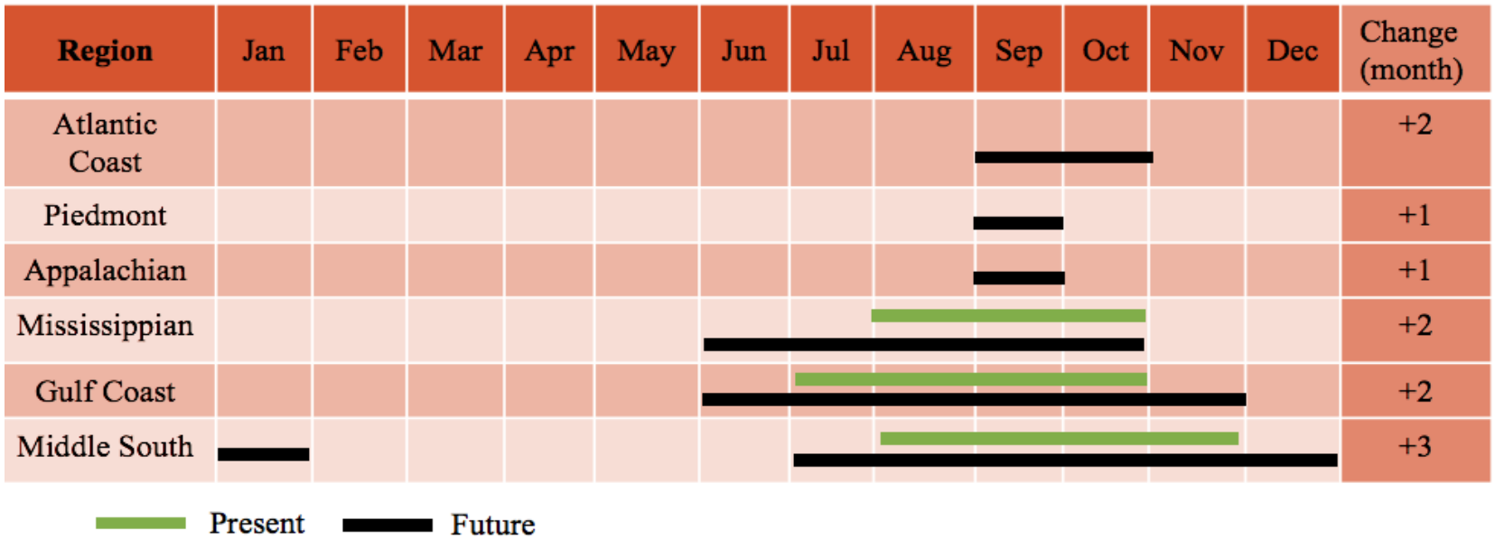
Mega-Fires (>200,000 acres) typically have expensive control efforts, high environmental and human health impacts, and are predicted to continue increasing in frequency. Between 2041 and 2070, national projections suggest the number of months with high to extreme fire potential will increase by 1-3 months (Figure 1) and the fire potential, using Keetch-Byram Drought Index, will increase by one grade (e.g. moderate risk to high risk). This shift towards a greater potential for mega-fires will likely reduce the window with acceptable conditions for conducting prescribed burns. Estimates of future emissions in the southeastern U.S. from mega-fires is complex due to contrasting predicted increases in mega-fire occurrences and decreases in fuel loading under some regional climate change scenarios (PI Yong Liu). A second study yields similar results, suggesting mega-fire risk from 2046-2065 will increase in limited areas along the east coast, including the Carolinas, Georgia, and Florida seaboards. Additionally, fire seasons should increase across many parts of the U.S., primarily due to earlier spring fire potentials (PI Sim Larkin).
Future Air Quality
After the year 2050, wildland fire emissions in many parts of the United States may surpass other emission sources to become the dominant source of summertime PM2.5. For the eastern U.S., this may cause many states in the region to not attain the EPA National Ambient Air Quality PM2.5 Standard of 12 µg m-3 due to winds transporting fire emissions from western boreal forest fires (PI Jeffrey Pierce). The increase in potential smoke impacts is predicted to be relatively lower in coastal states than in interior eastern states due to westerly prevailing winds pushing smoke into the Atlantic Ocean (PI Sim Larkin).
References
- Engebretson, J. M., Hall, T. E., Blades, J. J., Olsen, C. S., Toman, E., & Frederick, S. S. (2016). Characterizing public tolerance of smoke from wildland fires in communities across the United States. Journal of Forestry, 114, 601-609.
- Garcia-Menendez, F., Yano, A., Hu, Y., Odman, M. T. (2010). An adaptive grid version of CMAQ for improving the resolution of plumes. Atmospheric Pollution Research, 1, 239-249, doi:10.5094/APR.2010.031
- Liu, Y., Goodrick, S. L., & Stanturf, J. A. (2013). Future U.S. wildfire potential trends projected using a dynamically downscaled climate change scenario. Forest Ecology and Management, 294, 120-135.
- Olsen, C. S., Mazzotta, D. K., Toman, E., & Fischer, A. P. (2014). Communicating about smoke from wildland fire: Challenges and opportunities for managers. Environmental Management, 54, 571-582.