Predicting Smoke Movement: An Introduction to Smoke Models
Dakota Wagner, David Godwin, Christian Fernandez
Originally Published by: Daniel Stratton, Anthony Matthews, Alan Long
Publication ID: Fact Sheet 2025-1 Published: 2011 Revised: 2025, 2026
(View PDF)
Predicting Smoke Movement: An Overview
Smoke management is a critical component in prescribed burn planning. In many cases, it is the first consideration in the planning process, with the rest of the prescription tailored to ensure smoke disperses in the desired direction. Forecasts from the National Weather Service are valuable for predicting smoke movement. However, factors such as fire size and fuel conditions also influence smoke concentration and dispersal. To account for these variables, a range of models have been developed to provide predictions of smoke dispersal. This fact sheet introduces four of these models and describes the types of inputs, outputs, and fire situations for each.
Smoke Models
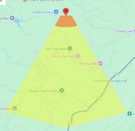
Simple Smoke Screening Tool
The Simple Smoke Screening Tool, available for free through the Florida Department of Agriculture, is a user-friendly graphical model designed for burns of less than 300 acres during the daytime. The user provides a point or burned area on an interactive map, and the tool generates a cone on the map conservatively projecting the smoke impact area. This process replicates a practice that was traditionally performed with a ruler and compass or protractor. It uses wind direction forecasts, acres burned, fuel type (grass, shrubs, litter, or slash), and ignition method to model smoke impacts. However, it only identifies the downwind smoke impact zone; it does not predict potential smoke concentrations, which depend on factors such as fuel conditions as well as the timing and quantity of smoke production.
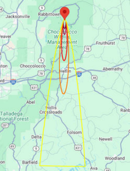
VSmoke & VSmoke-Web
VSmoke and VSmoke-Web are planning tools designed to estimate downwind particulate matter concentrations at fixed distances and assess visibility through the smoke plume at each point. These tools help predict air quality and potential health impacts from prescribed burns. Both versions generate smoke plume overlays on maps or satellite images, displaying expected particulate matter concentrations relative to the Air Quality Index (AQI) thresholds and associated health risks. Users input data such as weather conditions (wind speed and direction, mixing height, and atmospheric stability), fuel characteristics (type, moisture, and loading), burn unit size, and ignition method. Outputs include peak hourly PM2.5 concentrations and visibility (visibility predictions are under development as of November 2024).
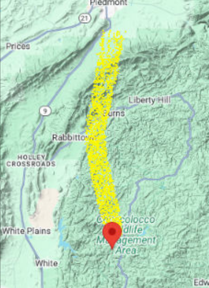
PB-Piedmont & PB-Piedmont-Web
PB-Piedmont and PB-Piedmont-Web are models specifically for predicting nighttime smoke movement, which is especially useful for assessing potential impacts to roadways. Developed for use in areas with modest elevation changes and pronounced drainages, including the Piedmont region of the southeast, it uses NOAA’s North American Mesoscale (NAM) forecast data, updated every six hours for projections up to 36 hours. Inputs include burn location, ignition time, terrain parameters such as acres burned, and fuel type (grass or trees). Outputs include smoke dispersion predictions that account for changing weather conditions and surface topography, with results provided as maps or datasets that are valid for 48 hours.
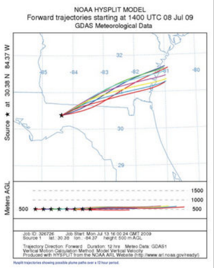
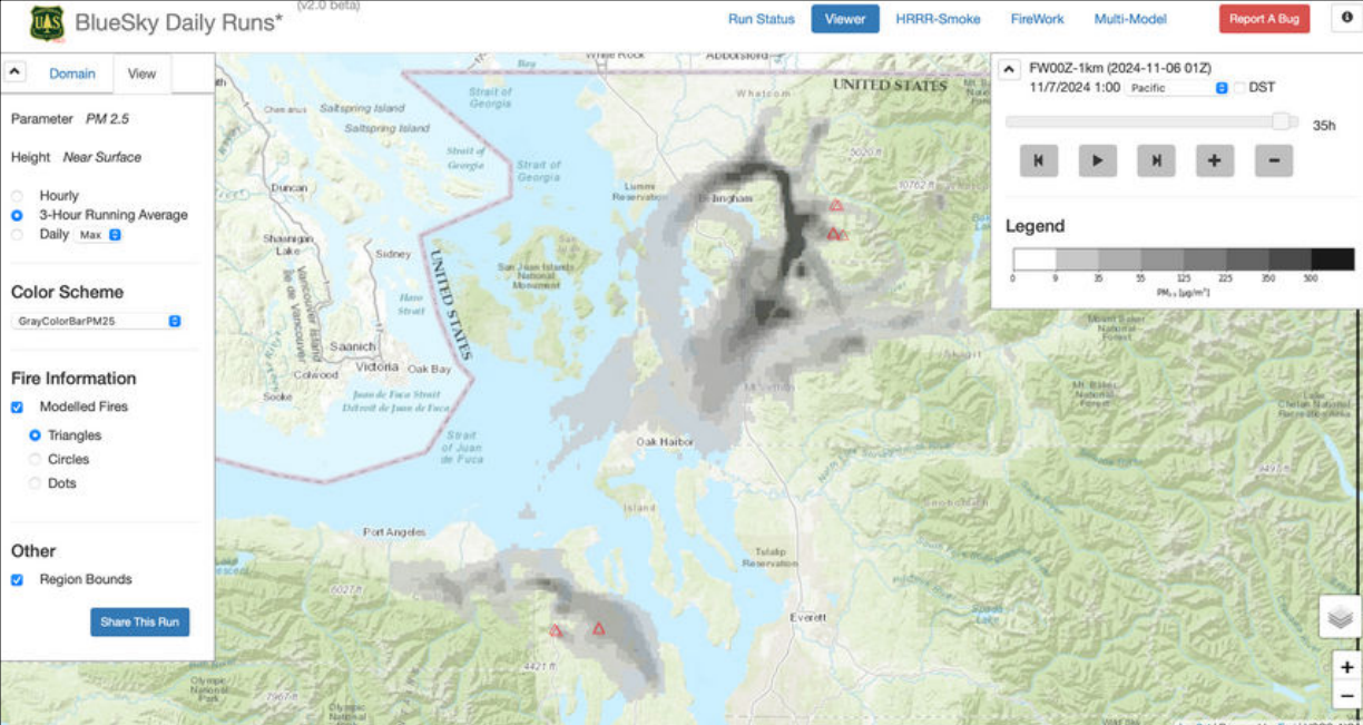
BlueSky Playground
BlueSky Playground is a web-based tool that predicts emissions scenarios, including plume rise and smoke dispersion. Inputs include details about the fuels (using the Fuel Characteristic Classification System), fuel moisture, fuel consumption, and burning conditions. BlueSky Playground connects with VSmoke or HYSPLIT to produce final reports. The HYSPLIT model utilizes NOAA weather forecasts to predict the dispersion and trajectory of smoke and other air pollutants, rather than using user-input meteorology data. Outputs include emissions and smoke dispersion models, which can be downloaded as KMZ files for mapping or as PDF documents.
Smoke Modeling Tools:
- Simple Smoke Screening Tool http://fireweather.fdacs.gov/Simple-Smoke/
- VSmoke https://webcam.srs.fs.usda.gov/tools/vsmoke/download.shtml
- VSmoke-Web https://weather.gfc.state.ga.us/GoogleVsmoke/vsmoke-Good2.html
- PB-Piedmont https://piedmont.dri.edu/
- BlueSky Playground https://tools.airfire.org/playground/v3.5/emissionsinputs.php
Additional Information and Resources:
Research on smoke management and developing improved smoke modeling tools has been a key focus over several decades. As technology advances, these models continue to evolve, offering greater accuracy and usability for practitioners. Below are additional resources to support the use of the four models discussed in this fact sheet, along with other helpful references.
- BlueSky Playground V3 Demo and Tutorial https://info.airfire.org/playground/playground-v3-5-help/demo-exercise
- PB-Piedmont Factsheet https://southernfireexchange.org/new-sfe-smoke-model-fact-sheet/pb-piedmontfactsheet/
- PB-Piedmont User Guide https://piedmont.dri.edu//PB_Piedmont_User_Guide_v4.pdf
- HYSPLIT https://www.ready.noaa.gov/HYSPLIT.php
- Superfog Factsheet https://southernfireexchange.org/wp-content/uploads/2014-2.pdf
- Nighttime Smoke and Fog Factsheet https://southernfireexchange.org/wp-content/uploads/2011-2.pdf
- Smoke Management Guide for Prescribed Fire (NWCG) https://www.nwcg.gov/publications/pms420-3
- Smoke Management Guidebook for Prescribed Burning in the Southern Region
https://southernfireexchange.org/smoke-management-guidebook-for-prescribed-burning-in-the-southern-region/ - Guidebook to Prescribed Burning in the Southern Region https://sref.info/resources/publications/guidebook-for-prescribed-burning-in-the-southern-region