Fuel Models for the Southeast
Dakota Wagner, David Godwin, Christian Fernandez
Publication ID: Fact Sheet 2025-4 Published: 2025 Revised: 2026
(View PDF)
Fire behavior fuel models are generalizations of vegetative fuel conditions that can aid in describing and predicting wildland fire behavior. Fuel models are tools that can help practitioners, wildland firefighters, and planners use complex fire behavior models to understand and anticipate how fires might behave regarding spread and intensity in various environments. Fuel models can be dynamic, as fuels change throughout the year and over time, and can vary within a single fuel type depending on conditions.
Why Fuel Models Were Created, and the "Original 13"
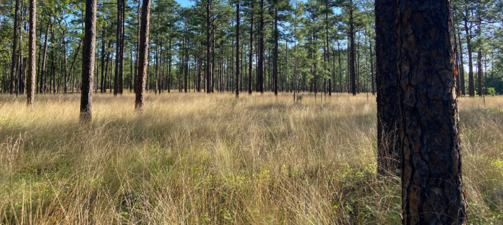
Fuel models were created to systematically predict potential fire behavior, enabling resource managers to prepare for fire suppression more effectively. In the 1970s, 11 fuel models were introduced by Richard Rothermel and then expanded to 13 by Frank Albini (see Table 1). The first fuel models were designed to represent suites of fuel loading and arrangement characteristics for use in the Rothermel fire spread and intensity model. The basic fuel model concept has stayed true through its evolution over the past 50 years, and it remains a useful tool for mathematically describing suites of fuel-type conditions that can be handled by modern fire behavior, emissions, and smoke models. The 13 are organized into four main groups: grass and grass-dominated, chaparral and shrub, timber litter, and slash. In the 1980s, Hal Anderson described the 13 fuel models and provided aids to selecting a fuel model through the use of photographic illustrations (see Additional Resources section).
| Fuel Model | Typical Fuel Complex |
|---|---|
| 1 | Short grass (1 foot) |
| 2 | Timber (grass and understory) |
| 3 | Tall grass (2.5 feet) |
| 4 | Chaparral (6 feet) |
| 5 | Brush (2 feet) |
| 6 | Dormant brush, hardwood slash* |
| 7 | Southern rough* |
| 8 | Closed timber litter |
| 9 | Hardwood litter |
| 10 | Timber (litter and understory) |
| 11 | Light logging slash |
| 12 | Medium logging slash |
| 13 | Heavy logging slash |
| *Added by Albini in 1976 | |
Southern Rough
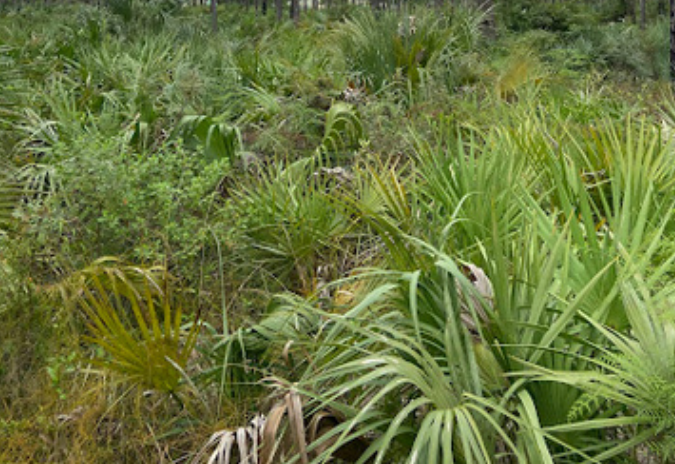
The Southern Rough fuel model, part of the Brush or Shrub category, represents natural fuels in areas with dense undergrowth, such as palmetto, gallberry, and other shrubs typical of the Southeastern U.S. Surface fires burn easily, with moderate to high flame lengths, and can ignite even at higher dead fuel moisture levels due to the flammability of surrounding live vegetation.
"The Standard 40" Fuel Models
Scott and Burgan’s 40 fuel models, introduced in 2005, address the limitations of previous models by incorporating regional and seasonal variations, making them especially useful for prescribed burning and year-round application in regions like the Southeast. Unlike static models, these dynamic models, which assume fixed live-to-dead fuel ratios, account for seasonal changes in herbaceous fuels. To select the appropriate fuel model, identify the dominant fire-carrying fuel type (between Non-Burnable (NB), Grass (GR), Grass-Shrub (GS), Shrub (SH), Timber-Understory (TU), Timber Litter (TL), and Slash-Blowdown (SB)), assess whether the region’s climate is humid or dry (e.g., typically subhumid to humid in the Southeast), and determine fuel loading and other fuel characteristics. The 40 fuel models can be referenced in three ways: by fuel model number, code, and/or name (Table 2). Fuel model numbers are primarily used in computer coding and map generation, while fuel model codes and names are commonly referenced in burn plans and communications among burn managers.
| Number | Code | Name |
|---|---|---|
| 124 | GS4 | High load, humid climate grass-shrub |
A Fuel Model Selection Guide can be found on pages 10 to 12 in Standard Fire Behavior Fuel Models: A Comprehensive Set for Use with Rothermel’s Surface Fire Spread Model (see Additional Resources section).
Fuel Characteristic Classification System
The Fuel Characteristic Classification System (FCCS) describes wildland fuel characteristics for hundreds of fuelbed descriptions across the continental U.S., Alaska, and Hawaii. It can predict surface fire behavior, fire effects, fuel consumption, and crown fire potential. While the Rothermel equation assumes homogeneous surface fuels, FCCS accounts for heterogeneous fuels across multiple strata. FCCS breaks fuels into six strata: canopy, shrubs, herbaceous fuels, downed wood, litter-lichen-moss (LLM), and ground fuels, with further categories and subcategories. The FCCS naming system typically represents fuels across multiple strata (Table 3).
FCCS fuel models can serve as inputs for models like Consume to estimate fuel consumption and emissions. These outputs can be crosswalked to systems such as the First Order Fire Effects Model (FOFEM) to augment fire effects analysis, providing fire managers additional predictions about fuel consumption and smoke production.
| Pixel Value | Label | Fuel Loading (tons/acre) |
|---|---|---|
| 275 | Chestnut-white-northern red oak forest | 53.89 |
| 191 | Longleaf pine-slash pine/gallberry forest-managed with prescribed fire | 22.76 |
Identifying Appropriate Fuel Models Using LANDFIRE
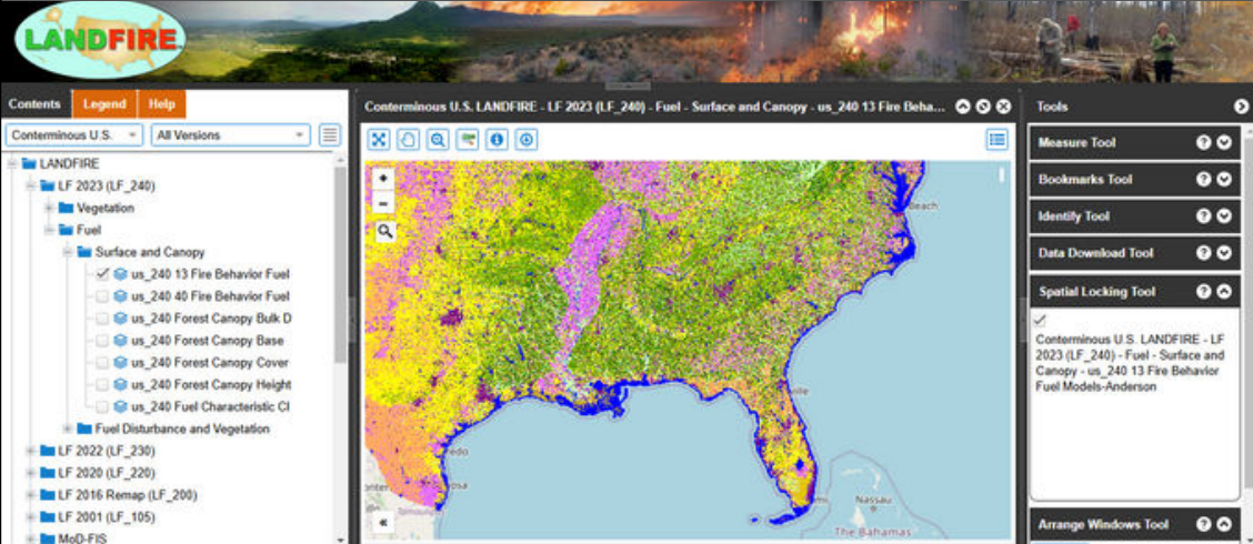
The LANDFIRE Viewer is a valuable tool for identifying potential fuel models for a burn unit. To access this resource, visit landfire.gov and click “LF Map Viewer” in the bottom left of the home page. Once the LANDFIRE Map Viewer has loaded, navigate through the Contents pane on the left-hand side of the screen, opening the folder titled “LANDFIRE”. From here, open the folder titled “LF2023”, then the folder titled “Vegetation”. From here, deselect the “us_240 Existing Vegetation Type” layer. After deselecting that layer, open the folder titled “Fuel” under the “LF2023” folder, followed by “Surface and Canopy”. From the “Surface and Canopy” folder, various fuel models–including the Original 13 (titled “us_240 13 Fire Behavior Fuel”), the Standard 40 (titled “us_240 40 Fire Behavior Fuel”), and FCCS (titled “us_240 Fuel Characteristic CIass”)–can be toggled and viewed. The selected model should best represent the expected fire behavior of the burn unit.
The Next Generation of Fuel Models
Fuel models provide insights to guide decisions about fire suppression strategies, prescribed burn planning, and resource allocation. However, traditional fuel models have often lacked accuracy for Southeastern ecosystems. With technological advancements, the next generation of fuel models will leverage laser scanning/LiDAR to generate detailed 3D representations of fuel data. As of 2025, the use of TLS (terrestrial laser scanning) for ground-based fuels characterization and monitoring is rapidly advancing through partnerships among researchers and land managers. Emerging platforms, such as FastFuels (see Additional Resources section), integrate existing fuel and spatial data with cutting-edge modeling techniques to depict complex 3D fuel structures across landscapes. These advancements will enable fire practitioners and land managers to understand fuel distribution better and more effectively monitor fuels treatment and fire effects. For additional information about terrestrial 3D laser scanning, see the Additional Resources section.
Additional Resources
- Aids to Determining Fuel Models For Estimating Fire Behavior (Anderson, 1982) https://www.fs.usda.gov/rm/pubs_int/int_gtr122.pdf
- Standard Fire Behavior Fuel Models: A Comprehensive Set for Use with Rothermel’s Surface Fire Spread Model (Scott & Burgan, 2005) https://www.fs.usda.gov/rm/pubs/rmrs_gtr153.pdf
- Fuel Characteristic Classification System version 3.0 https://research.fs.usda.gov/treesearch/45283
- FastFuels https://research.fs.usda.gov/treesearch/68657
- Terrestrial 3D Laser Scanning for Ecosystem and Fire Effects Monitoring (USFS)
https://research.fs.usda.gov/treesearch/67919 - Interagency LiDAR Monitoring & Research Applications (USGS) https://dmsdata.cr.usgs.gov/lidar-monitoring/
- Introduction to [Rothermel] Fire Behavior Fuel Models (World of Wildland Fire 2017)
https://www.youtube.com/watch?v=XCa10jUWAKI - How to Select a [Standard 40] Fire Behavior Fuel Model (World of Wildland Fire 2021)
https://www.youtube.com/watch?v=q0kVff3MUec - Modeling Dynamic Fuels with an Index System (MoD-FIS) for the Southeast United States
https://landfire.gov/fuel/lfmodfis/dailymodfis - Fire Assessment: Evaluating Expected Fire Behavior (National Wildfire Coordinating Group)
https://www.nwcg.gov/publications/pms437/fire-assessment/evaluating-expected-fire-behavior - LANDFIRE Fuel Model Downloads https://landfire.gov/data/FullExtentDownloads
- Fuel Characteristic Classification System (FCCS) Field Sampling and Fuelbed Development Guide (Prichard
et al. 2019) https://www.fs.usda.gov/pnw/pubs/pnw_gtr972.pdf - LANDFIRE Map Viewer https://www.landfire.gov/viewer/
- Surface Fuel Model Selection (National Wildfire Coordinating Group)
https://www.nwcg.gov/publications/pms437/fuels/surface-fuel-model-selection