
Relationships Among Wildfire, Prescribed Fire and Drought at Fort Benning, Georgia
Leslie Boby1, Jennifer Fawcett2, Alan Long3
1Southern Region Extension Forestry
2North Carolina State University
3Southern Fire Exchange
Publication ID: Fact Sheet 2018-1 Published: 2018 Revised: 2021, 2026
(View PDF)
Introduction
Prescribed fire is an important tool for meeting multiple management objectives such as reducing fuels and improving wildlife habitat. Most natural resource and fire managers believe that the risks of wildfire are often reduced by recent fires, and a growing body of research has shown this to be the case. A recent Southern Fire Exchange Fact Sheet What the research says: Prescribed fire and wildfire risk reduction summarized several studies over the last 50 years that contributed to our understanding of the role of previous fires in mitigating wildfires in the South. An important conclusion was that wildfire risk reduction may only last a few years depending on the ecosystems involved. This fact sheet provides a more in-depth review of one of those studies, which was a long-term landscape scale evaluation of interactions between prescribed fire and wildfire at Fort Benning Army Base in west central Georgia. The study reported by Addington, et al. (2015) examined the incidence of, and area burned by, wildfires and prescribed fires over a 30-year period. The study also explored the relationships between weather factors, especially drought, and prescribed and wildfire area.
Thirty Years of Fire Records and Weather Data
Prescribed fire has been used as a land management tool to reduce fuels and the severity of wildfires for more than 60 years at Fort Benning. The base has also had frequent, unintended wildfires ignited by military training exercises that often involve live ordnance, grenades and flares. Fort Benning land managers have been recording data on prescribed fires, wildfire ignitions and area burned since the early 1980s. Addington et al. examined these fire records, with a specific focus on the 30-year window from 1982-2012. For that period of time, annual wildfire and prescribed fire summaries were developed which included fire occurrence and the area burned by wildfires and prescribed fire by date. Weather data were obtained from the U.S. National Oceanic and Atmospheric Administration (NOAA) National Climatic Data Center as well as from individual remote weather stations in the area. Weather data were processed through the FireFamilyPlus software application to synthesize four fire-related weather variables: Palmer Drought Severity Index (PDSI), Keetch-Byram Drought index (KBDI), Energy Release Component (ERC) and the Canadian Forest Fire Weather Index (FWI). Weather information and indices were modelled together with prescribed fire area to determine how each variable and the interactions among variables influenced annual wildfire incidence and acres burned.
Study Site
Fort Benning, GA
- 182,000 acre U.S Army military base
- 145,000 acres of forested land
- 90,000 acres of upland pine subject to fire management
- Frequent unintended ignitions from infantry training exercises
Vegetation:
- Pine-dominated uplands, hardwood-dominated lower slopes and bottomlands.
- Historically, this area would have been longleaf pine and mixed-pine forests.
Prescribed Fire History and Management
- Historic fire frequency every 1-5 years
- Currently 30,000 acres burned annually using prescribed fire.
- Goal of 2-3 year fire return interval.
- Regular prescribed fire since mid-1950s.
- Prescribed fire used primarily for fuels reduction since the 1990s.
- Prescribed fire also for ecological objectives such as habitat for red-cockaded woodpeckers.
Annual Wildfire Incidence Decreased Over Time
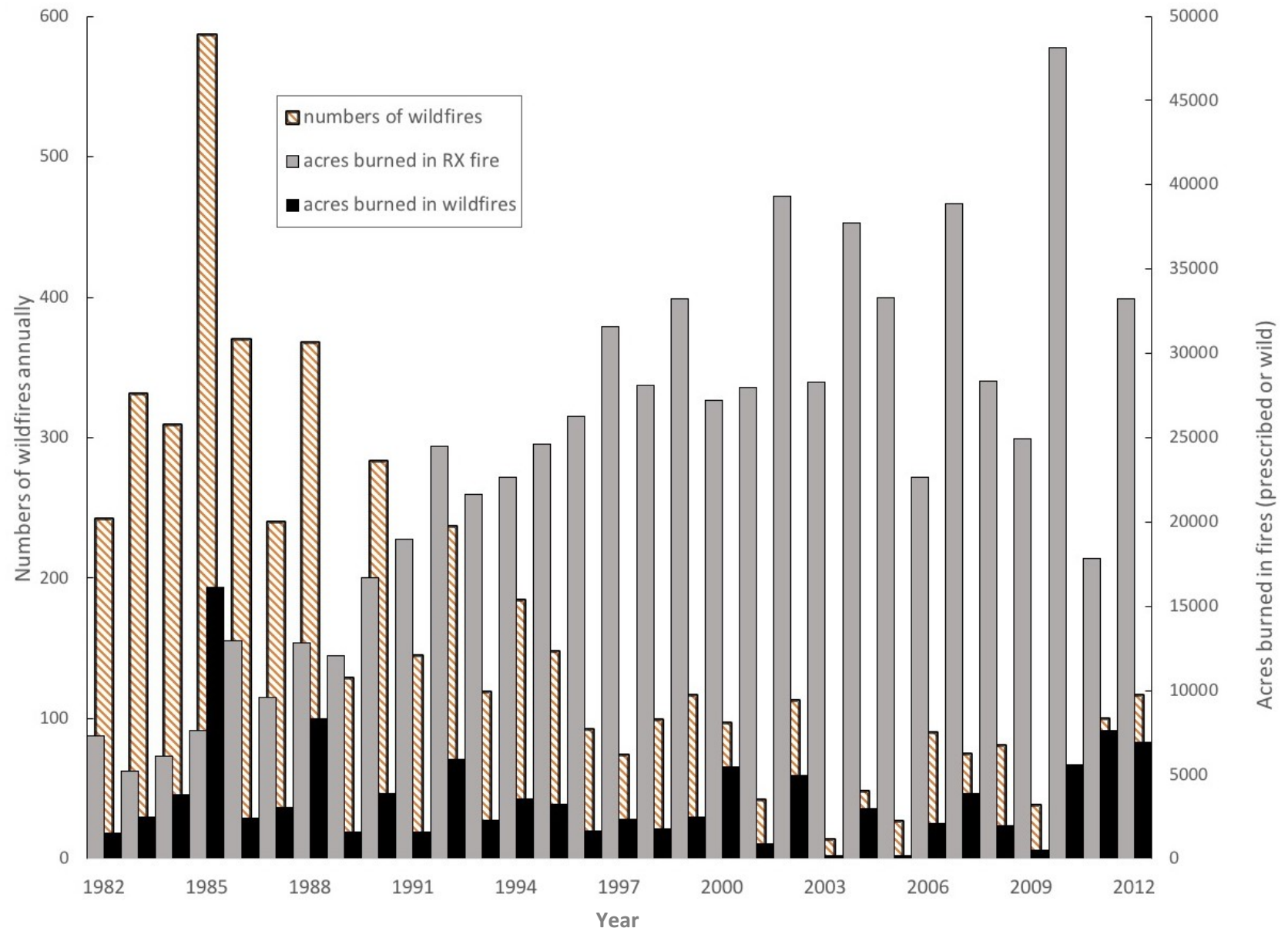
In the 1980’s, about 300-500 wildfires occurred each year, with a gradual decline into the mid-1990’s when annual wildfires stabilized at or below 100 wildfires per year (Figure 1). The number of acres of prescribed fire increased throughout this same time period (Figure 1) from an average of ~12,000 acres per year (13% of the upland pine) from 1982-1992 to ~31,000 acres per year from 2002-2012 (34% of the upland pine). Over the 30-year period the decline in wildfires is sharply related to the increase in prescribed fire area.
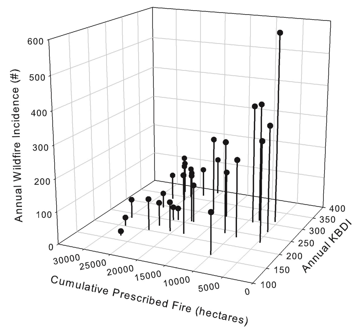
Several factors other than annual prescribed fire acreage appeared to influence the decrease in wildfires, including: the number and acres of fires in the previous year (prescribed or wild), as well as drought. When modeled together, these factors explained 80% of variation in the wildfire incidence data. Of the four weather and drought indices, KBDI was the most meaningful variable in the models for predicting wildfire area and incidence. Drought, expressed as the KBDI variable, tended to increase wildfire incidence such that prescribed fires had less influence on wildfires in drought years.
Area Burned in Wildfires Inconsistent Over Time
The area burned in wildfires each year, over the 30-year period, did not show the same consistent trend as did the number of wildfires (Figure 1). The only strong predictors in the regression models for annual wildfire area were prescribed fire area in the previous year and drought, with drought largely accounting for the scattered years with high wildfire acreage. Given the inconsistent trend in wildfire area, the regression models only explained 54% of the variation in the annual wildfire area over time. The study mentioned that in all but one year the actual number of acres burned by wildfires was much smaller when compared to the number of acres prescribed burned and thus, the area burned was not as influential.
Area burned in wildfires is more complex to evaluate than incidence of wildfires, as the rate at which a wildfire grows after an ignition is based on factors for which descriptive data did not exist in this study, such as response time for a fire crew, their suppression strategy, fuel type and conditions, and
Annual Wildfire Incidence
Is Strongly Related to:
- Current-year prescribed fire area
- Previous-year prescribed fire area
- Previous wildfire incidence
- Drought
Annual Wildfire Area Burned
Is Related to:
- Previous-year prescribed fire area
- Drought
topography. The increase in area burned by wildfires in the final three years of the study (Figure 1) were due, in part, to Fort Benning adopting a “let burn” policy for wildfires that met weather and fuel windows for prescribed fire. This policy was a direct outcome of the substantial fuel reductions achieved over the previous decades of prescribed burning. Since land managers had successfully decreased fuel loads across the base, they evaluated each wildfire individually and allowed fires to spread when conditions were favorable in order to meet land management objectives.
Prescribed Fire has less Influence on Wildfires During Drought Years
During drought years with high KBDI (Figure 2), study results suggested that the combined effects of drought and low levels of cumulative (current plus previous years) prescribed fire result in much greater incidence of wildfires than in years with low annual KBDI and/or large prescribed fire acres. Considering fire behavior, drought conditions increase the risk of ignition and rate of fire spread because of low fuel moisture. At the same time, reduced prescribed burning in the current and previous year result in more area with fuels ready to ignite and carry a fire. The combined effects of dry fuels and larger unburned areas with susceptible fuels produced the five years of highest wildfire incidence (on the right side of Figure 2).
Conclusion
Results from this observational research are consistent with several other studies in the Southeastern United States. Addington, et al. concluded that “…our study provides evidence of the cumulative effect of landscape-scale prescribed fire in reducing wildfire activity over time.” Furthermore, forests at Fort Benning, like most of the forests in the southeastern United States, are a fire-prone landscape and they will inevitably burn, whether or not it is intentional. Therefore, the authors suggest: “Prescribed fire offers a means of controlling the distribution of fire on the landscape both spatially and temporally, with benefits extending to smoke and emissions management.” Prescribed fire will decrease the number of wildfires in those locations, in subsequent years and generally decrease the acreage burned in those wildfires except during drought conditions. However, additional studies suggest that the lagged wildfire mitigation effects probably only last two to four years depending on the ecosystem. This study provides strong evidence of the importance of a prescribed fire program with a frequent fire return interval for creating and maintaining pyrogenic Southern U.S. landscapes with low wildfire incidence.
References
- Addington, Robert N., Hudson, Stephen J., Hiers, J.Kevin, Hurteau, Matthew D., Hutcherson, Thomas F., Matusick, George and Parker, James M. 2015. Relationships among wildfire, prescribed fire, and drought in a fire-prone landscape in the southeastern United States. International Journal of Wildland Fire. 24, 778-783. https://doi.org/10.1071/WF14187
- Long, A and A. Oxarart. 2017. What the research says: Prescribed fire and wildfire risk reduction. SFE Fact Sheet 2017-1. https://southernfireexchange.org/factsheet-2017-1/