A member of the JFSP Fire Science Exchange Network. Some materials may not be available at this time as we update our website and resources to meet accessibility standards.

NOAA HRRR Interactive System Maps Predicted Smoke Movement

The NOAA HRRR-Smoke and Fire Map provides visualizations of predicted near-surface smoke concentration for the lower-48 US states.

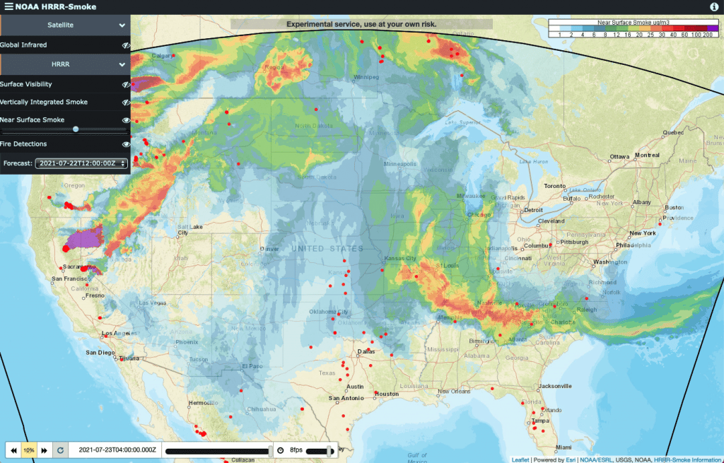
The NOAA-HRRR-Smoke and Fire Mapping System provides an interactive web-based tool to track and observe current and predicted smoke concentrations across the US lower-48 states. More information about the NOAA-HRRR model. A recent article about wildfire smoke in the New York Times featured the NOAA-HRR Smoke Mapping System as well a general discussion of some potential health impacts from reduced air quality.

Recent Posts

Flier describing a call for applications for the summer 2026 EFNet Graduate Research experience on the WUI.

Call for Applications: EFNet Graduate Research Experience on WUI

  Call for Applications: EFNet Graduate Research Experience on the WUI The Eastern Fire Network (EFNet) recently announced a call for applications for their summer ...
Read More →
Collage of pictures from volume 15 issue 8 of Fire Lines.

New Fire Lines Newsletter (vol. 15 is. 8)

  New Fire Lines Newsletter: Volume 15, Issue 8 The latest issue (Volume 15, Issue 8) of the Southern Fire Exchange “Fire Lines” newsletter has ...
Read More →

New Fire Lines Newsletter (vol. 15 is. 7)

  New Fire Lines Newsletter: Volume 15, Issue 7 The latest issue (Volume 15, Issue 7) of the Southern Fire Exchange “Fire Lines” newsletter has ...
Read More →
Scroll to Top