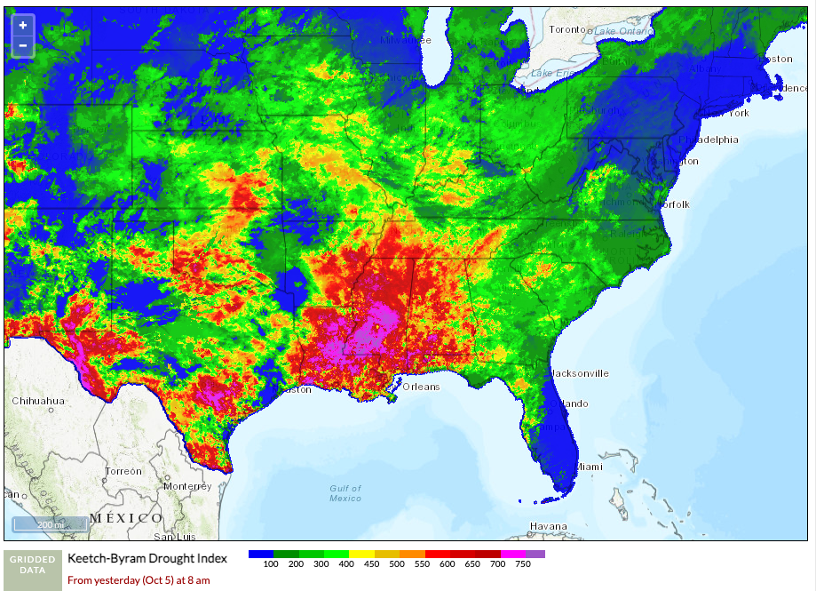
It’s been a long hot and dry summer for parts of the region and we’re dry going into the fall season. The above image is gridded KBDI for the region as of Thursday, October 5, 2023. You can find the data source and mapping information at the Fire Weather Intelligence Portal from the State Climate Office of North Carolina.
For more information about the impacts of this past summer, a two-page Fuels and Fire Behavior Advisory (below) was released on October 2, 2023 for Louisiana, and portions of Arkansas, Mississippi, Alabama, and the Florida Panhandle.
The advisory includes the following concerns for firefighters and the public:
- Extreme fire line intensity is to be expected during both initial attack and extended attack.
- Typical barriers to fire spread, like roads, rivers, and hardwood bottoms may not be relied upon to stop fire progression.
- Active fire behavior may extend into the overnight hours during periods of poor RH recovery.
- Spotting up to ¼ of a mile away has routinely been reported, including small initial attack fires.
- Reburn of scorched needle cast continues to occur during the
- days or weeks after suppression, while roots burning underground may result in green trees falling.
- Critical fire weather may be associated with but is not limited to: compressional warming in unstable pre-frontal environments, dry cold fronts followed by windy and dry conditions, strong high pressure over the northern U.S. combined with low pressure south of the advisory area, subsidence adjacent to tropical cyclones, sea breeze fronts and erratic winds associated with outflow from nearby thunderstorms.