A member of the JFSP Fire Science Exchange Network. Some materials may not be available at this time as we update our website and resources to meet accessibility standards.

USFS and EPA Fire and Smoke Map

A photo of the US Forest Service and US EPA fire and smoke map. It shows air quality monitor status using a green through red color scheme.

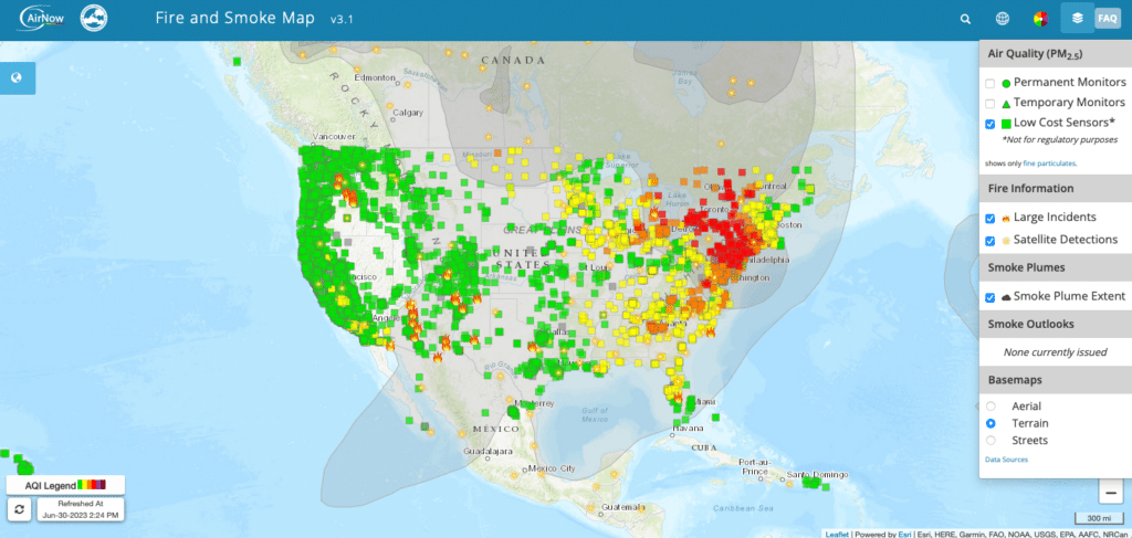
Are you getting questions about smoke and poor air quality this summer? Are you looking for a national map of modeled smoke plumes and observed air quality conditions? The Fire and Smoke Map is your go-to resource to address those questions. Be sure to add the website to your list of favorites so that you can find it next time things get smoky or you’re thinking about burning.

Recent Posts

Flier describing a call for applications for the summer 2026 EFNet Graduate Research experience on the WUI.

Call for Applications: EFNet Graduate Research Experience on WUI

  Call for Applications: EFNet Graduate Research Experience on the WUI The Eastern Fire Network (EFNet) recently announced a call for applications for their summer ...
Read More →
Collage of pictures from volume 15 issue 8 of Fire Lines.

New Fire Lines Newsletter (vol. 15 is. 8)

  New Fire Lines Newsletter: Volume 15, Issue 8 The latest issue (Volume 15, Issue 8) of the Southern Fire Exchange “Fire Lines” newsletter has ...
Read More →

New Fire Lines Newsletter (vol. 15 is. 7)

  New Fire Lines Newsletter: Volume 15, Issue 7 The latest issue (Volume 15, Issue 7) of the Southern Fire Exchange “Fire Lines” newsletter has ...
Read More →
Scroll to Top