SFE-CAFMS Joint Webinar: Historical Fire Regimes and Vegetation Patterns of the Blue Ridge and Vicinity
Historical Fire Regimes & Vegetation Patterns of the Blue Ridge & Vicinity When: Sept. 25th, 1:00-2:00 p.m. ET Hosted by: Southern Fire Exchange and Consortium of Appalachians Fire Managers and
Partner Webinar: Leveraging the Treatment and Wildfire Interagency Geodatabase (TWIG)
Leveraging the Treatment and Wildfire Interagency Geodatabase (TWIG): An Open-Access Tool for Exploring National Wildfire and Fuel Treatment Interactions When: July 23, 3:00 – 4:30 ET Hosted by: Fire Learning
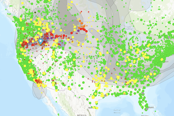
New and Improved Fire and Smoke Map 4.0
If you have checked out or used the Fire and Smoke Map in the past, you might want to check it out again. The USDA Forest Service and the EPA
SFE Webinar: Increasing Large Wildfires in the Eastern United States
A free one-hour webinar from the University of Florida IFAS and the Southern Fire Exchange. Society of American Foresters CFE Credit Expected. Presenter: Victoria M Donovan, Ph.D., Assistant Professor of
Partner Event: Remote Sensing of Burned Area Symposium
Remote Sensing of Burned Area Symposium January 25, 2023 11:30 – 1:00 PM ET Hosted by Tall Timbers Research Station and the US Geological Survey In-person and Virtual Tall Timbers
Southern Area Fire Environment Outlook
The Southern Area Interagency Coordination Center (SACC) has published the fall 2022 Southern Area Fire Environment Outlook as an ESRI StoryMap. The dynamic maps and links are accompanied by narrative
Partner Webinar: SFE FireMap 2.0
SE FireMap 2.0 Webinar: Tuesday, September 20th 2:00 PM ET Free and open to all. Register now for a free and open webinar on the Southeast (SE) FireMap on Tuesday,
Prescribed Burn Geodatabase for the Southeastern United States
Tall Timbers Research Station is undertaking a project that aims to do the following: 1) Survey Southeastern states to understand their prescribed fire permitting systems. 2) Develop minimum attribution for
FEMA Launches National Risk Index Map
A new mapping tool from FEMA allows communities to identify their risk to 18 natural hazards, including wildfire. Use the map here.